Table 1. Personal Income and Per Capita Personal Income by Metropolitan Area 1999–2001
| |
Personal Income |
Per capita personal income1 |
| |
(millions of dollars) |
Percent change 2000-20012 |
(dollars) |
Rank in U.S. |
| Area name |
1999 |
2000 |
2001 |
1999 |
2000 |
2001 |
| United States3 |
7,779,521 |
8,398,871 |
8,677,490 |
3.3 |
27,880 |
29,760 |
30,413 |
. |
| Metropolitan portion |
6,633,219 |
7,185,218 |
7,428,050 |
3.4 |
29,616 |
31,680 |
32,336 |
. |
| Nonmetropolitan portion |
1,146,302 |
1,213,653 |
1,249,440 |
2.9 |
20,818 |
21,901 |
22,472 |
. |
| |
| Consolidated Metropolitan Statistical Areas |
| Chicago-Gary-Kenosha, IL-IN-WI |
298,061 |
321,557 |
331,277 |
3.0 |
32,771 |
35,028 |
35,751 |
. |
| Cincinnati-Hamilton, OH-KY-IN |
57,342 |
60,627 |
62,758 |
3.5 |
29,124 |
30,559 |
31,419 |
. |
| Cleveland-Akron, OH |
86,292 |
90,686 |
92,446 |
1.9 |
29,293 |
30,773 |
31,368 |
. |
| Dallas-Fort Worth, TX |
159,254 |
175,700 |
180,072 |
2.5 |
31,106 |
33,412 |
33,247 |
. |
| Denver-Boulder-Greeley, CO |
85,768 |
96,583 |
100,284 |
3.8 |
33,878 |
37,158 |
37,607 |
. |
| Detroit-Ann Arbor-Flint, MI |
169,736 |
180,724 |
182,894 |
1.2 |
31,182 |
33,067 |
33,314 |
. |
| Houston-Galveston-Brazoria, TX |
143,594 |
157,975 |
167,954 |
6.3 |
31,218 |
33,632 |
34,916 |
. |
| Los Angeles-Riverside-Orange County, CA |
450,650 |
484,858 |
508,187 |
4.8 |
27,842 |
29,488 |
30,360 |
. |
| Miami-Fort Lauderdale, FL |
100,297 |
107,399 |
112,446 |
4.7 |
26,289 |
27,576 |
28,325 |
. |
| Milwaukee-Racine, WI |
51,745 |
54,859 |
56,513 |
3.0 |
30,716 |
32,436 |
33,308 |
. |
| New York-No. New Jersey-Long Island, NY-NJ-CT-PA |
774,091 |
846,883 |
872,675 |
3.0 |
36,943 |
40,046 |
40,949 |
. |
| Philadelphia-Wilmington-Atlantic City, PA-NJ-DE-MD |
194,331 |
209,100 |
216,243 |
3.4 |
31,526 |
33,750 |
34,750 |
. |
| Portland-Salem, OR-WA |
64,163 |
69,645 |
71,520 |
2.7 |
28,638 |
30,619 |
30,822 |
. |
| Sacramento-Yolo, CA |
49,898 |
54,257 |
57,143 |
5.3 |
28,235 |
29,996 |
30,571 |
. |
| San Francisco-Oakland-San Jose, CA |
283,381 |
333,236 |
326,824 |
-1.9 |
40,605 |
47,180 |
45,778 |
. |
| Seattle-Tacoma-Bremerton, WA |
121,336 |
129,721 |
132,586 |
2.2 |
34,428 |
36,386 |
36,669 |
. |
| Washington-Baltimore, DC-MD-VA-WV |
264,060 |
287,952 |
302,650 |
5.1 |
35,119 |
37,684 |
38,915 |
. |
| |
| Metropolitan Statistical Areas4 |
| Abilene, TX |
3,001 |
3,184 |
3,051 |
-4.2 |
23,757 |
25,179 |
24,304 |
246 |
| Akron, OH* |
19,258 |
20,362 |
20,905 |
2.7 |
27,784 |
29,258 |
29,953 |
91 |
| Albany, GA |
2,646 |
2,776 |
2,852 |
2.7 |
21,951 |
22,975 |
23,275 |
277 |
| Albany-Schenectady-Troy, NY |
24,982 |
26,732 |
27,956 |
4.6 |
28,583 |
30,503 |
31,789 |
62 |
| Albuquerque, NM |
17,295 |
18,436 |
19,531 |
5.9 |
24,489 |
25,794 |
27,030 |
159 |
| Alexandria, LA |
2,885 |
3,070 |
3,297 |
7.4 |
22,877 |
24,282 |
26,053 |
181 |
| Allentown-Bethlehem-Easton, PA |
17,521 |
18,796 |
19,520 |
3.8 |
27,579 |
29,421 |
30,317 |
86 |
| Altoona, PA |
2,999 |
3,146 |
3,173 |
0.8 |
23,110 |
24,382 |
24,682 |
234 |
| Amarillo, TX |
5,052 |
5,344 |
5,367 |
0.4 |
23,407 |
24,468 |
24,365 |
243 |
| Anchorage, AK |
8,674 |
9,200 |
9,755 |
6.0 |
33,447 |
35,307 |
36,949 |
22 |
| Ann Arbor, MI* |
18,277 |
20,022 |
20,125 |
0.5 |
32,072 |
34,403 |
33,965 |
38 |
| Anniston, AL |
2,376 |
2,392 |
2,452 |
2.5 |
20,675 |
21,486 |
22,035 |
295 |
| Appleton-Oshkosh-Neenah, WI |
9,604 |
10,290 |
10,746 |
4.4 |
27,030 |
28,626 |
29,579 |
97 |
| Asheville, NC |
5,760 |
6,114 |
6,256 |
2.3 |
25,747 |
26,970 |
27,378 |
148 |
| Athens, GA |
3,405 |
3,613 |
3,755 |
3.9 |
22,527 |
23,452 |
24,085 |
252 |
| Atlanta, GA |
126,446 |
139,019 |
144,477 |
3.9 |
31,534 |
33,507 |
33,769 |
41 |
| Atlantic-Cape May, NJ* |
10,367 |
11,135 |
11,273 |
1.2 |
29,404 |
31,328 |
31,511 |
66 |
| Auburn-Opelika, AL |
2,023 |
2,161 |
2,210 |
2.3 |
17,918 |
18,714 |
18,923 |
312 |
| Augusta-Aiken, GA-SC |
10,819 |
11,489 |
11,876 |
3.4 |
22,805 |
24,033 |
24,721 |
233 |
| Austin-San Marcos, TX |
36,852 |
40,712 |
41,673 |
2.4 |
30,560 |
32,185 |
31,511 |
66 |
| Bakersfield, CA |
12,815 |
13,637 |
14,236 |
4.4 |
19,553 |
20,543 |
21,021 |
306 |
| Baltimore, MD* |
78,303 |
83,987 |
87,832 |
4.6 |
30,824 |
32,837 |
34,039 |
36 |
| Bangor, ME (NECMA) |
3,229 |
3,461 |
3,651 |
5.5 |
22,287 |
23,889 |
25,097 |
221 |
| Barnstable-Yarmouth, MA (NECMA) |
7,348 |
7,881 |
8,159 |
3.5 |
33,557 |
35,303 |
36,135 |
28 |
| Baton Rouge, LA |
14,488 |
15,246 |
15,836 |
3.9 |
24,221 |
25,228 |
26,032 |
183 |
| Beaumont-Port Arthur, TX |
8,752 |
9,115 |
9,307 |
2.1 |
22,730 |
23,689 |
24,296 |
247 |
| Bellingham, WA |
3,699 |
3,950 |
4,192 |
6.1 |
22,474 |
23,567 |
24,564 |
239 |
| Benton Harbor, MI |
4,041 |
4,219 |
4,185 |
-0.8 |
24,941 |
25,942 |
25,826 |
189 |
| Bergen-Passaic, NJ* |
53,208 |
58,913 |
60,735 |
3.1 |
38,885 |
42,799 |
43,856 |
4 |
| Billings, MT |
3,202 |
3,450 |
3,635 |
5.4 |
24,869 |
26,628 |
27,891 |
137 |
| Biloxi-Gulfport-Pascagoula, MS |
8,064 |
8,502 |
8,685 |
2.2 |
22,336 |
23,304 |
23,679 |
266 |
| Binghamton, NY |
5,987 |
6,344 |
6,463 |
1.9 |
23,686 |
25,167 |
25,669 |
201 |
| Birmingham, AL |
25,654 |
27,170 |
28,450 |
4.7 |
27,969 |
29,437 |
30,620 |
81 |
| Bismarck, ND |
2,276 |
2,460 |
2,618 |
6.4 |
24,155 |
25,944 |
27,461 |
144 |
| Bloomington, IN |
2,763 |
2,979 |
3,062 |
2.8 |
22,964 |
24,684 |
25,302 |
213 |
| Bloomington-Normal, IL |
4,206 |
4,511 |
4,679 |
3.7 |
28,200 |
29,897 |
30,761 |
77 |
| Boise City, ID |
11,424 |
12,776 |
13,153 |
3.0 |
27,135 |
29,294 |
29,109 |
109 |
| Boston-Worcester-Lawrence-Lowell-Brocktn, MA-NH (NECMA) |
211,837 |
237,575 |
244,142 |
2.8 |
35,178 |
39,125 |
39,873 |
16 |
| Boulder-Longmont, CO* |
10,384 |
11,850 |
12,223 |
3.1 |
36,319 |
40,447 |
40,840 |
13 |
| Brazoria, TX* |
5,582 |
6,185 |
6,409 |
3.6 |
23,494 |
25,426 |
25,695 |
200 |
| Bremerton, WA* |
5,699 |
6,162 |
6,388 |
3.7 |
24,844 |
26,497 |
27,427 |
147 |
| Brownsville-Harlingen-San Benito, TX |
4,665 |
5,038 |
5,283 |
4.9 |
14,125 |
14,954 |
15,334 |
317 |
| Bryan-College Station, TX |
2,882 |
3,122 |
3,233 |
3.6 |
19,190 |
20,429 |
21,028 |
305 |
| Buffalo-Niagara Falls, NY |
30,386 |
31,895 |
32,454 |
1.8 |
25,902 |
27,284 |
27,852 |
139 |
| Burlington, VT (NECMA) |
5,579 |
6,035 |
6,360 |
5.4 |
28,315 |
30,250 |
31,591 |
64 |
| Canton-Massillon, OH |
10,160 |
10,635 |
10,830 |
1.8 |
24,964 |
26,133 |
26,620 |
171 |
| Casper, WY |
1,967 |
2,216 |
2,224 |
0.3 |
29,680 |
33,301 |
33,274 |
43 |
| Cedar Rapids, IA |
5,738 |
6,147 |
6,278 |
2.1 |
30,211 |
31,977 |
32,391 |
52 |
| Champaign-Urbana, IL |
4,296 |
4,656 |
4,863 |
4.4 |
24,048 |
25,874 |
26,808 |
168 |
| Charleston-North Charleston, SC |
12,671 |
13,594 |
14,177 |
4.3 |
23,199 |
24,694 |
25,543 |
204 |
| Charleston, WV |
6,728 |
7,104 |
7,442 |
4.8 |
26,638 |
28,256 |
29,847 |
94 |
| Charlotte-Gastonia-Rock Hill, NC-SC |
43,384 |
46,785 |
48,815 |
4.3 |
29,481 |
30,993 |
31,526 |
65 |
| Charlottesville, VA |
4,634 |
5,013 |
5,123 |
2.2 |
29,450 |
31,269 |
31,657 |
63 |
| Chattanooga, TN-GA |
11,947 |
12,694 |
12,738 |
0.3 |
25,823 |
27,254 |
27,213 |
155 |
| Cheyenne, WY |
2,191 |
2,333 |
2,469 |
5.8 |
27,052 |
28,547 |
30,074 |
90 |
| Chicago, IL* |
275,684 |
297,811 |
306,730 |
3.0 |
33,569 |
35,907 |
36,624 |
25 |
| Chico-Paradise, CA |
4,258 |
4,535 |
4,701 |
3.6 |
21,155 |
22,255 |
22,818 |
287 |
| Cincinnati, OH-KY-IN* |
48,424 |
51,222 |
53,075 |
3.6 |
29,561 |
31,040 |
31,967 |
59 |
| Clarksville-Hopkinsville, TN-KY |
4,319 |
4,673 |
4,802 |
2.8 |
21,079 |
22,510 |
23,017 |
282 |
| Cleveland-Lorain-Elyria, OH* |
67,035 |
70,324 |
71,541 |
1.7 |
29,757 |
31,241 |
31,807 |
61 |
| Colorado Springs, CO |
13,880 |
15,266 |
15,682 |
2.7 |
27,267 |
29,388 |
29,280 |
105 |
| Columbia, MO |
3,453 |
3,721 |
3,850 |
3.4 |
25,752 |
27,396 |
28,020 |
133 |
| Columbia, SC |
14,108 |
15,083 |
15,567 |
3.2 |
26,555 |
28,021 |
28,578 |
120 |
| Columbus, GA-AL |
6,478 |
6,872 |
7,136 |
3.8 |
23,654 |
24,992 |
25,909 |
186 |
| Columbus, OH |
44,563 |
47,519 |
49,093 |
3.3 |
29,228 |
30,737 |
31,343 |
69 |
| Corpus Christi, TX |
8,478 |
8,995 |
9,221 |
2.5 |
22,208 |
23,628 |
24,280 |
248 |
| Corvallis, OR |
2,191 |
2,317 |
2,403 |
3.7 |
27,995 |
29,650 |
30,709 |
78 |
| Cumberland, MD-WV |
2,014 |
2,114 |
2,201 |
4.1 |
19,656 |
20,756 |
21,694 |
302 |
| Dallas, TX* |
113,010 |
125,424 |
126,926 |
1.2 |
32,774 |
35,383 |
34,697 |
33 |
| Danville, VA |
2,194 |
2,319 |
2,335 |
0.7 |
19,894 |
21,074 |
21,280 |
304 |
| Davenport-Moline-Rock Island, IA-IL |
9,264 |
9,791 |
9,988 |
2.0 |
25,753 |
27,283 |
27,879 |
138 |
| Dayton-Springfield, OH |
26,119 |
27,251 |
27,811 |
2.1 |
27,402 |
28,677 |
29,340 |
103 |
| Daytona Beach, FL |
10,763 |
11,533 |
12,040 |
4.4 |
22,114 |
23,273 |
23,827 |
264 |
| Decatur, AL |
3,403 |
3,540 |
3,695 |
4.4 |
23,432 |
24,236 |
25,233 |
215 |
| Decatur, IL |
3,058 |
3,194 |
3,222 |
0.9 |
26,563 |
27,901 |
28,417 |
123 |
| Denver, CO* |
71,496 |
80,516 |
83,704 |
4.0 |
34,515 |
37,924 |
38,513 |
17 |
| Des Moines, IA |
13,766 |
14,545 |
15,318 |
5.3 |
30,550 |
31,777 |
32,991 |
47 |
| Detroit, MI* |
140,791 |
149,689 |
151,753 |
1.4 |
31,716 |
33,665 |
34,035 |
37 |
| Dothan, AL |
3,072 |
3,228 |
3,330 |
3.1 |
22,360 |
23,386 |
24,030 |
254 |
| Dover, DE |
2,877 |
3,047 |
3,084 |
1.2 |
22,906 |
23,974 |
23,940 |
260 |
| Dubuque, IA |
2,176 |
2,305 |
2,394 |
3.9 |
24,465 |
25,825 |
26,889 |
163 |
| Duluth-Superior, MN-WI |
5,984 |
6,389 |
6,571 |
2.8 |
24,615 |
26,202 |
26,873 |
166 |
| Dutchess County, NY* |
8,029 |
8,702 |
9,196 |
5.7 |
28,925 |
30,987 |
32,349 |
53 |
| Eau Claire, WI |
3,600 |
3,837 |
3,872 |
0.9 |
24,426 |
25,817 |
25,899 |
188 |
| El Paso, TX |
11,874 |
12,546 |
13,230 |
5.4 |
17,581 |
18,398 |
19,186 |
311 |
| Elkhart-Goshen, IN |
4,614 |
4,852 |
4,833 |
-0.4 |
25,544 |
26,436 |
26,050 |
182 |
| Elmira, NY |
2,150 |
2,298 |
2,325 |
1.2 |
23,549 |
25,246 |
25,638 |
202 |
| Enid, OK |
1,321 |
1,378 |
1,421 |
3.1 |
22,704 |
23,896 |
24,780 |
230 |
| Erie, PA |
6,618 |
6,975 |
7,156 |
2.6 |
23,527 |
24,847 |
25,495 |
206 |
| Eugene-Springfield, OR |
7,849 |
8,292 |
8,420 |
1.5 |
24,392 |
25,641 |
25,963 |
185 |
| Evansville-Henderson, IN-KY |
7,817 |
8,288 |
8,650 |
4.4 |
26,445 |
27,970 |
29,185 |
106 |
| Fargo-Moorhead, ND-MN |
4,533 |
4,811 |
4,992 |
3.8 |
26,216 |
27,538 |
28,372 |
124 |
| Fayetteville, NC |
7,151 |
7,587 |
7,777 |
2.5 |
23,710 |
25,054 |
25,729 |
198 |
| Fayetteville-Springdale-Rogers, AR |
6,813 |
7,356 |
7,936 |
7.9 |
22,464 |
23,461 |
24,585 |
237 |
| Flagstaff, AZ-UT |
2,558 |
2,771 |
2,884 |
4.1 |
21,086 |
22,577 |
23,311 |
275 |
| Flint, MI* |
10,667 |
11,013 |
11,016 |
0.0 |
24,556 |
25,204 |
25,105 |
219 |
| Florence, AL |
2,954 |
3,091 |
3,140 |
1.6 |
20,759 |
21,615 |
22,037 |
294 |
| Florence, SC |
2,903 |
3,103 |
3,251 |
4.8 |
23,107 |
24,666 |
25,742 |
197 |
| Fort Collins-Loveland, CO |
6,657 |
7,512 |
7,849 |
4.5 |
26,966 |
29,700 |
30,198 |
89 |
| Fort Lauderdale, FL* |
45,084 |
48,383 |
51,370 |
6.2 |
28,281 |
29,629 |
30,702 |
79 |
| Fort Myers-Cape Coral, FL |
11,477 |
12,523 |
13,563 |
8.3 |
26,568 |
28,215 |
29,540 |
99 |
| Fort Pierce-Port St. Lucie, FL |
9,064 |
9,608 |
10,033 |
4.4 |
28,653 |
29,965 |
30,601 |
83 |
| Fort Smith, AR-OK |
4,304 |
4,632 |
4,839 |
4.5 |
21,029 |
22,270 |
23,048 |
280 |
| Fort Walton Beach, FL |
4,344 |
4,531 |
4,768 |
5.2 |
25,698 |
26,505 |
27,674 |
142 |
| Fort Wayne, IN |
13,234 |
14,022 |
14,070 |
0.3 |
26,558 |
27,867 |
27,819 |
140 |
| Fort Worth-Arlington, TX* |
46,244 |
50,277 |
53,146 |
5.7 |
27,663 |
29,337 |
30,230 |
88 |
| Fresno, CA |
18,282 |
19,332 |
20,219 |
4.6 |
20,061 |
20,878 |
21,463 |
303 |
| Gadsden, AL |
2,121 |
2,211 |
2,253 |
1.9 |
20,397 |
21,400 |
21,865 |
298 |
| Gainesville, FL |
5,121 |
5,423 |
5,635 |
3.9 |
23,727 |
24,841 |
25,572 |
203 |
| Galveston-Texas City, TX* |
6,411 |
6,839 |
7,088 |
3.6 |
25,758 |
27,272 |
27,786 |
141 |
| Gary, IN* |
16,197 |
17,240 |
17,825 |
3.4 |
25,685 |
27,282 |
28,094 |
130 |
| Glens Falls, NY |
2,756 |
2,934 |
2,986 |
1.7 |
22,211 |
23,599 |
23,952 |
258 |
| Goldsboro, NC |
2,249 |
2,416 |
2,459 |
1.8 |
19,871 |
21,319 |
21,738 |
301 |
| Grand Forks, ND-MN |
2,264 |
2,388 |
2,444 |
2.3 |
23,125 |
24,562 |
25,351 |
212 |
| Grand Junction, CO |
2,699 |
2,922 |
3,007 |
2.9 |
23,509 |
25,019 |
25,366 |
210 |
| Grand Rapids-Muskegon-Holland, MI |
28,993 |
30,747 |
31,462 |
2.3 |
26,909 |
28,145 |
28,471 |
121 |
| Great Falls, MT |
1,908 |
2,013 |
2,072 |
2.9 |
23,669 |
25,106 |
26,016 |
184 |
| Greeley, CO* |
3,888 |
4,217 |
4,357 |
3.3 |
22,301 |
23,016 |
22,469 |
290 |
| Green Bay, WI |
6,431 |
6,834 |
7,005 |
2.5 |
28,605 |
30,052 |
30,535 |
85 |
| Greensboro-Winston-Salem-High Point, NC |
33,981 |
36,054 |
36,626 |
1.6 |
27,452 |
28,707 |
28,774 |
115 |
| Greenville, NC |
2,940 |
3,291 |
3,362 |
2.2 |
22,179 |
24,526 |
24,854 |
225 |
| Greenville-Spartanburg-Anderson, SC |
23,013 |
24,655 |
25,239 |
2.4 |
24,159 |
25,534 |
25,818 |
191 |
| Hagerstown, MD* |
3,035 |
3,257 |
3,375 |
3.6 |
23,139 |
24,655 |
25,404 |
209 |
| Hamilton-Middletown, OH* |
8,917 |
9,404 |
9,682 |
3.0 |
26,961 |
28,184 |
28,718 |
116 |
| Harrisburg-Lebanon-Carlisle, PA |
17,748 |
18,649 |
19,476 |
4.4 |
28,256 |
29,611 |
30,829 |
76 |
| Hartford, CT (NECMA) |
39,199 |
42,490 |
43,836 |
3.2 |
34,345 |
36,915 |
37,819 |
19 |
| Hattiesburg, MS |
2,282 |
2,412 |
2,533 |
5.0 |
20,628 |
21,517 |
22,351 |
291 |
| Hickory-Morganton-Lenoir, NC |
8,159 |
8,648 |
8,675 |
0.3 |
24,141 |
25,205 |
24,988 |
224 |
| Honolulu, HI |
25,385 |
26,644 |
27,511 |
3.3 |
28,882 |
30,420 |
31,115 |
72 |
| Houma, LA |
3,955 |
4,220 |
4,600 |
9.0 |
20,328 |
21,697 |
23,540 |
268 |
| Houston, TX* |
131,601 |
144,951 |
154,457 |
6.6 |
31,995 |
34,487 |
35,872 |
29 |
| Huntington-Ashland, WV-KY-OH |
6,319 |
6,626 |
6,841 |
3.2 |
20,002 |
21,021 |
21,793 |
299 |
| Huntsville, AL |
8,837 |
9,549 |
9,987 |
4.6 |
26,023 |
27,800 |
28,684 |
118 |
| Indianapolis, IN |
46,760 |
50,256 |
52,244 |
4.0 |
29,427 |
31,155 |
31,960 |
60 |
| Iowa City, IA |
3,094 |
3,343 |
3,524 |
5.4 |
28,172 |
30,018 |
31,203 |
71 |
| Jackson, MI |
3,705 |
3,909 |
3,902 |
-0.2 |
23,588 |
24,628 |
24,415 |
241 |
| Jackson, MS |
11,091 |
11,746 |
12,210 |
3.9 |
25,360 |
26,583 |
27,428 |
146 |
| Jackson, TN |
2,526 |
2,697 |
2,683 |
-0.5 |
23,740 |
25,076 |
24,674 |
235 |
| Jacksonville, FL |
29,903 |
32,189 |
33,416 |
3.8 |
27,475 |
29,161 |
29,625 |
96 |
| Jacksonville, NC |
3,300 |
3,448 |
3,559 |
3.2 |
22,056 |
22,952 |
23,945 |
259 |
| Jamestown, NY |
2,855 |
2,990 |
3,038 |
1.6 |
20,383 |
21,419 |
21,897 |
297 |
| Janesville-Beloit, WI |
3,783 |
3,936 |
3,976 |
1.0 |
24,961 |
25,802 |
25,908 |
187 |
| Jersey City, NJ* |
15,674 |
17,130 |
17,552 |
2.5 |
25,950 |
28,100 |
28,584 |
119 |
| Johnson City-Kingsport-Bristol, TN-VA |
10,233 |
10,894 |
11,282 |
3.6 |
21,409 |
22,676 |
23,473 |
271 |
| Johnstown, PA |
5,029 |
5,212 |
5,344 |
2.5 |
21,489 |
22,441 |
23,141 |
279 |
| Jonesboro, AR |
1,715 |
1,811 |
1,841 |
1.6 |
21,165 |
21,952 |
22,147 |
293 |
| Joplin, MO |
3,341 |
3,535 |
3,654 |
3.4 |
21,438 |
22,413 |
23,019 |
281 |
| Kalamazoo-Battle Creek, MI |
11,314 |
11,815 |
11,912 |
0.8 |
25,051 |
26,063 |
26,207 |
178 |
| Kankakee, IL* |
2,357 |
2,512 |
2,580 |
2.7 |
22,731 |
24,184 |
24,749 |
232 |
| Kansas City, MO-KS |
52,969 |
57,032 |
58,978 |
3.4 |
30,063 |
32,000 |
32,693 |
49 |
| Kenosha, WI* |
3,823 |
3,994 |
4,143 |
3.7 |
25,774 |
26,609 |
27,217 |
154 |
| Killeen-Temple, TX |
6,785 |
7,163 |
7,406 |
3.4 |
22,019 |
22,797 |
23,415 |
272 |
| Knoxville, TN |
17,138 |
18,356 |
19,035 |
3.7 |
25,147 |
26,636 |
27,330 |
152 |
| Kokomo, IN |
2,778 |
2,920 |
2,847 |
-2.5 |
27,419 |
28,762 |
28,038 |
132 |
| La Crosse, WI-MN |
3,166 |
3,356 |
3,525 |
5.0 |
25,121 |
26,420 |
27,626 |
143 |
| Lafayette, LA |
8,131 |
8,641 |
9,247 |
7.0 |
21,167 |
22,395 |
23,881 |
262 |
| Lafayette, IN |
4,179 |
4,476 |
4,642 |
3.7 |
23,034 |
24,416 |
25,141 |
218 |
| Lake Charles, LA |
4,016 |
4,118 |
4,383 |
6.4 |
21,895 |
22,436 |
23,935 |
261 |
| Lakeland-Winter Haven, FL |
10,600 |
11,275 |
11,800 |
4.7 |
22,173 |
23,224 |
23,991 |
256 |
| Lancaster, PA |
12,415 |
13,387 |
13,699 |
2.3 |
26,534 |
28,382 |
28,863 |
110 |
| Lansing-East Lansing, MI |
11,508 |
12,116 |
12,287 |
1.4 |
25,740 |
27,023 |
27,253 |
153 |
| Laredo, TX |
2,690 |
2,924 |
3,125 |
6.9 |
14,232 |
15,011 |
15,508 |
316 |
| Las Cruces, NM |
2,887 |
2,991 |
3,173 |
6.1 |
16,602 |
17,090 |
17,984 |
314 |
| Las Vegas, NV-AZ |
40,406 |
43,969 |
46,155 |
5.0 |
26,882 |
27,777 |
27,916 |
136 |
| Lawrence, KS |
2,116 |
2,293 |
2,441 |
6.4 |
21,268 |
22,892 |
24,129 |
251 |
| Lawton, OK |
2,348 |
2,466 |
2,561 |
3.9 |
20,233 |
21,520 |
22,672 |
289 |
| Lewiston-Auburn, ME (NECMA) |
2,418 |
2,559 |
2,680 |
4.7 |
23,389 |
24,637 |
25,752 |
196 |
| Lexington, KY |
12,808 |
13,743 |
14,002 |
1.9 |
27,023 |
28,585 |
28,849 |
111 |
| Lima, OH |
3,721 |
3,877 |
3,929 |
1.3 |
24,027 |
24,983 |
25,353 |
211 |
| Lincoln, NE |
6,852 |
7,358 |
7,833 |
6.5 |
27,689 |
29,289 |
30,872 |
75 |
| Little Rock-North Little Rock, AR |
15,270 |
16,189 |
17,028 |
5.2 |
26,378 |
27,663 |
28,845 |
112 |
| Longview-Marshall, TX |
4,769 |
5,074 |
5,346 |
5.4 |
22,829 |
24,305 |
25,439 |
208 |
| Los Angeles-Long Beach, CA* |
264,408 |
282,700 |
296,233 |
4.8 |
28,017 |
29,605 |
30,611 |
82 |
| Louisville, KY-IN |
29,253 |
31,202 |
32,298 |
3.5 |
28,677 |
30,357 |
31,251 |
70 |
| Lubbock, TX |
5,601 |
6,041 |
6,090 |
0.8 |
23,261 |
24,872 |
24,788 |
229 |
| Lynchburg, VA |
4,890 |
5,202 |
5,315 |
2.2 |
22,884 |
24,174 |
24,665 |
236 |
| Macon, GA |
7,798 |
8,289 |
8,556 |
3.2 |
24,309 |
25,644 |
26,265 |
177 |
| Madison, WI |
13,746 |
14,929 |
15,753 |
5.5 |
32,477 |
34,848 |
36,201 |
27 |
| Mansfield, OH |
3,911 |
4,100 |
4,193 |
2.3 |
22,172 |
23,340 |
23,989 |
257 |
| McAllen-Edinburg-Mission, TX |
7,066 |
7,601 |
8,170 |
7.5 |
12,712 |
13,238 |
13,788 |
318 |
| Medford-Ashland, OR |
4,285 |
4,574 |
4,688 |
2.5 |
23,906 |
25,152 |
25,505 |
205 |
| Melbourne-Titusville-Palm Bay, FL |
11,522 |
12,567 |
13,079 |
4.1 |
24,405 |
26,300 |
26,888 |
164 |
| Memphis, TN-AR-MS |
32,011 |
33,607 |
35,084 |
4.4 |
28,431 |
29,513 |
30,559 |
84 |
| Merced, CA |
3,717 |
3,867 |
4,033 |
4.3 |
17,977 |
18,268 |
18,461 |
313 |
| Miami, FL* |
55,213 |
59,016 |
61,077 |
3.5 |
24,860 |
26,093 |
26,594 |
173 |
| Middlesex-Somerset-Hunterdon, NJ* |
45,573 |
50,577 |
51,677 |
2.2 |
39,400 |
43,051 |
43,292 |
6 |
| Milwaukee-Waukesha, WI* |
46,584 |
49,423 |
50,907 |
3.0 |
31,134 |
32,898 |
33,780 |
40 |
| Minneapolis-St. Paul, MN-WI |
101,664 |
110,764 |
115,330 |
4.1 |
34,671 |
37,152 |
38,131 |
18 |
| Missoula, MT |
2,174 |
2,373 |
2,498 |
5.3 |
22,935 |
24,696 |
25,818 |
191 |
| Mobile, AL |
11,729 |
12,372 |
12,765 |
3.2 |
21,846 |
22,847 |
23,400 |
273 |
| Modesto, CA |
9,582 |
10,253 |
10,568 |
3.1 |
21,846 |
22,791 |
22,677 |
288 |
| Monmouth-Ocean, NJ* |
36,488 |
40,335 |
41,934 |
4.0 |
32,730 |
35,668 |
36,543 |
26 |
| Monroe, LA |
3,226 |
3,409 |
3,541 |
3.9 |
21,918 |
23,151 |
24,171 |
249 |
| Montgomery, AL |
8,236 |
8,698 |
8,994 |
3.4 |
24,870 |
26,078 |
26,830 |
167 |
| Muncie, IN |
2,798 |
2,977 |
3,031 |
1.8 |
23,559 |
25,088 |
25,493 |
207 |
| Myrtle Beach, SC |
4,333 |
4,693 |
4,847 |
3.3 |
22,590 |
23,694 |
24,021 |
255 |
| Naples, FL |
9,693 |
10,365 |
10,940 |
5.6 |
39,548 |
40,772 |
41,269 |
11 |
| Nashville, TN |
36,409 |
39,065 |
40,554 |
3.8 |
29,973 |
31,599 |
32,338 |
54 |
| Nassau-Suffolk, NY* |
104,726 |
113,140 |
115,641 |
2.2 |
38,264 |
40,978 |
41,559 |
10 |
| New Haven-Bridgprt-Stamfrd-Danbry-Wtrbry, CT* |
74,560 |
80,841 |
83,358 |
3.1 |
43,925 |
47,286 |
48,453 |
3 |
| New London-Norwich, CT (NECMA) |
7,969 |
8,492 |
8,635 |
1.7 |
30,939 |
32,723 |
33,112 |
45 |
| New Orleans, LA |
33,672 |
35,278 |
37,431 |
6.1 |
25,159 |
26,385 |
28,048 |
131 |
| New York, NY* |
337,749 |
368,463 |
379,472 |
3.0 |
36,529 |
39,501 |
40,450 |
14 |
| Newark, NJ* |
75,429 |
84,027 |
87,193 |
3.8 |
37,314 |
41,291 |
42,550 |
7 |
| Newburgh, NY-PA* |
9,654 |
10,370 |
10,875 |
4.9 |
25,292 |
26,609 |
27,343 |
150 |
| Norfolk-Virginia Beach-Newport News, VA-NC |
38,799 |
41,376 |
43,516 |
5.2 |
24,905 |
26,288 |
27,452 |
145 |
| Oakland, CA* |
84,550 |
96,400 |
98,073 |
1.7 |
35,764 |
40,086 |
39,963 |
15 |
| Ocala, FL |
5,540 |
5,889 |
6,077 |
3.2 |
21,727 |
22,624 |
22,910 |
284 |
| Odessa-Midland, TX |
5,984 |
6,470 |
6,619 |
2.3 |
24,927 |
27,389 |
27,920 |
134 |
| Oklahoma City, OK |
25,953 |
28,152 |
29,564 |
5.0 |
24,117 |
25,928 |
26,970 |
162 |
| Olympia, WA* |
5,284 |
5,715 |
6,016 |
5.3 |
25,790 |
27,426 |
28,266 |
127 |
| Omaha, NE-IA |
21,652 |
23,174 |
24,151 |
4.2 |
30,416 |
32,234 |
33,249 |
44 |
| Orange County, CA* |
93,187 |
101,280 |
106,284 |
4.9 |
33,093 |
35,446 |
36,647 |
24 |
| Orlando, FL |
41,313 |
44,684 |
46,064 |
3.1 |
25,692 |
26,974 |
27,003 |
161 |
| Owensboro, KY |
2,088 |
2,237 |
2,300 |
2.8 |
22,860 |
24,424 |
25,095 |
222 |
| Panama City, FL |
3,391 |
3,575 |
3,678 |
2.9 |
22,886 |
24,115 |
24,575 |
238 |
| Parkersburg-Marietta, WV-OH |
3,423 |
3,564 |
3,617 |
1.5 |
22,578 |
23,593 |
24,055 |
253 |
| Pensacola, FL |
9,090 |
9,720 |
10,101 |
3.9 |
22,169 |
23,549 |
24,140 |
250 |
| Peoria-Pekin, IL |
9,365 |
9,829 |
10,083 |
2.6 |
26,909 |
28,309 |
29,139 |
108 |
| Philadelphia, PA-NJ* |
162,176 |
174,534 |
180,280 |
3.3 |
31,896 |
34,186 |
35,192 |
31 |
| Phoenix-Mesa, AZ |
83,347 |
91,777 |
96,047 |
4.7 |
26,223 |
27,991 |
28,337 |
125 |
| Pine Bluff, AR |
1,601 |
1,663 |
1,708 |
2.7 |
19,023 |
19,745 |
20,387 |
308 |
| Pittsburgh, PA |
68,830 |
72,987 |
76,679 |
5.1 |
29,092 |
30,966 |
32,626 |
51 |
| Pittsfield, MA (NECMA) |
3,822 |
4,113 |
4,205 |
2.2 |
28,264 |
30,511 |
31,363 |
68 |
| Pocatello, ID |
1,518 |
1,593 |
1,651 |
3.6 |
20,098 |
21,081 |
21,780 |
300 |
| Portland, ME (NECMA) |
8,016 |
8,521 |
9,092 |
6.7 |
30,373 |
32,036 |
34,041 |
35 |
| Portland-Vancouver, OR-WA* |
56,125 |
61,258 |
62,926 |
2.7 |
29,594 |
31,801 |
31,971 |
58 |
| Providence-Warwick-Pawtucket, RI (NECMA) |
26,040 |
27,809 |
29,051 |
4.5 |
27,251 |
28,817 |
29,824 |
95 |
| Provo-Orem, UT |
6,469 |
7,063 |
7,339 |
3.9 |
17,887 |
19,046 |
19,271 |
310 |
| Pueblo, CO |
3,009 |
3,194 |
3,308 |
3.6 |
21,464 |
22,517 |
22,954 |
283 |
| Punta Gorda, FL |
3,393 |
3,608 |
3,753 |
4.0 |
24,195 |
25,361 |
25,800 |
193 |
| Racine, WI* |
5,161 |
5,436 |
5,606 |
3.1 |
27,398 |
28,762 |
29,550 |
98 |
| Raleigh-Durham-Chapel Hill, NC |
35,568 |
39,128 |
40,772 |
4.2 |
30,613 |
32,681 |
32,998 |
46 |
| Rapid City, SD |
2,217 |
2,359 |
2,446 |
3.7 |
25,185 |
26,577 |
27,181 |
156 |
| Reading, PA |
9,892 |
10,563 |
10,898 |
3.2 |
26,668 |
28,208 |
28,835 |
113 |
| Redding, CA |
3,754 |
4,029 |
4,211 |
4.5 |
23,176 |
24,595 |
25,175 |
216 |
| Reno, NV |
11,199 |
12,216 |
13,018 |
6.6 |
33,648 |
35,781 |
36,988 |
21 |
| Richland-Kennewick-Pasco, WA |
4,288 |
4,639 |
4,967 |
7.1 |
22,685 |
24,074 |
25,259 |
214 |
| Richmond-Petersburg, VA |
29,131 |
31,331 |
32,619 |
4.1 |
29,513 |
31,348 |
32,268 |
55 |
| Riverside-San Bernardino, CA* |
70,928 |
76,681 |
80,842 |
5.4 |
22,238 |
23,382 |
23,840 |
263 |
| Roanoke, VA |
6,482 |
6,899 |
7,138 |
3.5 |
27,529 |
29,250 |
30,249 |
87 |
| Rochester, MN |
3,870 |
4,181 |
4,447 |
6.4 |
31,571 |
33,488 |
35,110 |
32 |
| Rochester, NY |
30,339 |
31,715 |
32,846 |
3.6 |
27,675 |
28,863 |
29,870 |
93 |
| Rockford, IL |
9,387 |
9,838 |
9,889 |
0.5 |
25,483 |
26,429 |
26,335 |
176 |
| Rocky Mount, NC |
3,097 |
3,512 |
3,613 |
2.9 |
21,604 |
24,546 |
25,164 |
217 |
| Sacramento, CA* |
45,588 |
49,579 |
52,350 |
5.6 |
28,457 |
30,249 |
30,906 |
74 |
| Saginaw-Bay City-Midland, MI |
10,350 |
10,854 |
10,792 |
-0.6 |
25,663 |
26,927 |
26,749 |
170 |
| St. Cloud, MN |
3,822 |
4,095 |
4,221 |
3.1 |
23,098 |
24,361 |
24,802 |
227 |
| St. Joseph, MO |
2,306 |
2,473 |
2,536 |
2.6 |
22,628 |
24,106 |
24,799 |
228 |
| St. Louis, MO-IL |
77,424 |
82,714 |
85,596 |
3.5 |
29,838 |
31,729 |
32,666 |
50 |
| Salem, OR* |
8,037 |
8,388 |
8,595 |
2.5 |
23,366 |
24,080 |
24,402 |
242 |
| Salinas, CA |
11,096 |
11,802 |
12,230 |
3.6 |
28,001 |
29,270 |
29,901 |
92 |
| Salt Lake City-Ogden, UT |
32,685 |
35,039 |
36,295 |
3.6 |
24,748 |
26,176 |
26,780 |
169 |
| San Angelo, TX |
2,374 |
2,519 |
2,592 |
2.9 |
22,846 |
24,230 |
25,104 |
220 |
| San Antonio, TX |
39,188 |
42,152 |
43,742 |
3.8 |
24,920 |
26,355 |
26,887 |
165 |
| San Diego, CA |
84,585 |
92,986 |
97,241 |
4.6 |
30,322 |
32,910 |
33,883 |
39 |
| San Francisco, CA* |
85,910 |
101,736 |
100,048 |
-1.7 |
49,788 |
58,702 |
57,714 |
1 |
| San Jose, CA* |
76,443 |
93,928 |
87,479 |
-6.9 |
45,733 |
55,677 |
51,579 |
2 |
| San Luis Obispo-Atascadero-Paso Robles, CA |
6,191 |
6,772 |
7,011 |
3.5 |
25,429 |
27,341 |
27,917 |
135 |
| Santa Barbara-Santa Maria-Lompoc, CA |
12,071 |
13,179 |
13,541 |
2.7 |
30,414 |
32,961 |
33,739 |
42 |
| Santa Cruz-Watsonville, CA* |
8,362 |
9,687 |
9,426 |
-2.7 |
32,966 |
37,866 |
36,865 |
23 |
| Santa Fe, NM |
4,347 |
4,646 |
4,910 |
5.7 |
29,680 |
31,365 |
32,920 |
48 |
| Santa Rosa, CA* |
14,293 |
16,204 |
16,173 |
-0.2 |
31,522 |
35,193 |
34,671 |
34 |
| Sarasota-Bradenton, FL |
19,928 |
21,512 |
22,545 |
4.8 |
34,247 |
36,292 |
37,212 |
20 |
| Savannah, GA |
7,581 |
8,069 |
8,418 |
4.3 |
25,998 |
27,509 |
28,422 |
122 |
| Scranton-Wilkes-Barre-Hazleton, PA |
14,983 |
15,863 |
16,399 |
3.4 |
23,878 |
25,436 |
26,439 |
174 |
| Seattle-Bellevue-Everett, WA* |
93,047 |
99,291 |
101,059 |
1.8 |
38,811 |
41,025 |
41,229 |
12 |
| Sharon, PA |
2,615 |
2,786 |
2,821 |
1.2 |
21,657 |
23,180 |
23,512 |
269 |
| Sheboygan, WI |
3,032 |
3,212 |
3,314 |
3.2 |
27,052 |
28,486 |
29,409 |
100 |
| Sherman-Denison, TX |
2,415 |
2,607 |
2,633 |
1.0 |
22,117 |
23,482 |
23,366 |
274 |
| Shreveport-Bossier City, LA |
8,994 |
9,416 |
9,748 |
3.5 |
22,989 |
24,000 |
24,812 |
226 |
| Sioux City, IA-NE |
2,964 |
3,084 |
3,192 |
3.5 |
23,921 |
24,842 |
25,768 |
194 |
| Sioux Falls, SD |
5,036 |
5,403 |
5,694 |
5.4 |
29,874 |
31,129 |
32,154 |
57 |
| South Bend, IN |
6,949 |
7,321 |
7,486 |
2.3 |
26,228 |
27,534 |
28,098 |
128 |
| Spokane, WA |
10,012 |
10,877 |
11,044 |
1.5 |
24,100 |
25,977 |
26,107 |
180 |
| Springfield, IL |
5,665 |
6,032 |
6,277 |
4.1 |
28,135 |
29,929 |
31,037 |
73 |
| Springfield, MO |
7,590 |
8,149 |
8,519 |
4.5 |
23,600 |
24,933 |
25,756 |
195 |
| Springfield, MA (NECMA) |
15,685 |
16,838 |
17,473 |
3.8 |
25,834 |
27,649 |
28,705 |
117 |
| State College, PA |
3,234 |
3,423 |
3,618 |
5.7 |
23,897 |
25,175 |
26,396 |
175 |
| Steubenville-Weirton, OH-WV |
2,772 |
2,924 |
2,985 |
2.1 |
20,800 |
22,207 |
22,876 |
285 |
| Stockton-Lodi, CA |
12,223 |
13,192 |
13,753 |
4.3 |
22,127 |
23,212 |
23,155 |
278 |
| Sumter, SC |
2,044 |
2,150 |
2,191 |
1.9 |
19,500 |
20,519 |
21,009 |
307 |
| Syracuse, NY |
18,396 |
19,390 |
19,810 |
2.2 |
25,119 |
26,474 |
27,021 |
160 |
| Tacoma, WA* |
17,306 |
18,554 |
19,124 |
3.1 |
24,985 |
26,354 |
26,601 |
172 |
| Tallahassee, FL |
6,953 |
7,304 |
7,507 |
2.8 |
24,743 |
25,621 |
26,127 |
179 |
| Tampa-St. Petersburg-Clearwater, FL |
64,205 |
69,119 |
71,843 |
3.9 |
27,101 |
28,748 |
29,379 |
102 |
| Terre Haute, IN |
3,252 |
3,433 |
3,482 |
1.4 |
21,755 |
23,033 |
23,493 |
270 |
| Texarkana, TX-Texarkana AR |
2,680 |
2,852 |
2,887 |
1.2 |
20,698 |
21,983 |
22,150 |
292 |
| Toledo, OH |
16,611 |
17,203 |
17,385 |
1.1 |
26,862 |
27,825 |
28,098 |
128 |
| Topeka, KS |
4,491 |
4,783 |
4,973 |
4.0 |
26,499 |
28,127 |
29,144 |
107 |
| Trenton, NJ* |
13,000 |
14,386 |
15,041 |
4.5 |
37,311 |
40,911 |
42,317 |
8 |
| Tucson, AZ |
19,129 |
20,412 |
21,384 |
4.8 |
23,077 |
24,048 |
24,767 |
231 |
| Tulsa, OK |
22,044 |
23,738 |
24,903 |
4.9 |
27,604 |
29,486 |
30,650 |
80 |
| Tuscaloosa, AL |
3,788 |
3,984 |
4,145 |
4.0 |
23,037 |
24,134 |
25,041 |
223 |
| Tyler, TX |
4,541 |
4,898 |
5,131 |
4.7 |
26,288 |
27,920 |
28,824 |
114 |
| Utica-Rome, NY |
6,819 |
7,151 |
7,306 |
2.2 |
22,741 |
23,863 |
24,452 |
240 |
| Vallejo-Fairfield-Napa, CA* |
13,823 |
15,281 |
15,626 |
2.3 |
27,069 |
29,280 |
29,289 |
104 |
| Ventura, CA* |
22,128 |
24,197 |
24,828 |
2.6 |
29,768 |
31,974 |
32,232 |
56 |
| Victoria, TX |
2,069 |
2,217 |
2,300 |
3.7 |
24,638 |
26,391 |
27,158 |
157 |
| Vineland-Millville-Bridgeton, NJ* |
3,165 |
3,320 |
3,468 |
4.5 |
21,633 |
22,675 |
23,616 |
267 |
| Visalia-Tulare-Porterville, CA |
6,917 |
7,209 |
7,549 |
4.7 |
18,965 |
19,539 |
20,166 |
309 |
| Waco, TX |
4,663 |
4,888 |
5,029 |
2.9 |
22,044 |
22,837 |
23,302 |
276 |
| Washington, DC-MD-VA-WV* |
182,722 |
200,708 |
211,443 |
5.3 |
37,693 |
40,536 |
41,754 |
9 |
| Waterloo-Cedar Falls, IA |
2,964 |
3,169 |
3,300 |
4.1 |
23,193 |
24,770 |
25,826 |
189 |
| Wausau, WI |
3,252 |
3,457 |
3,573 |
3.4 |
25,936 |
27,455 |
28,274 |
126 |
| West Palm Beach-Boca Raton, FL |
44,869 |
47,656 |
50,676 |
6.3 |
40,172 |
41,945 |
43,626 |
5 |
| Wheeling, WV-OH |
3,365 |
3,513 |
3,597 |
2.4 |
21,819 |
22,984 |
23,783 |
265 |
| Wichita, KS |
14,626 |
15,258 |
16,161 |
5.9 |
26,887 |
27,940 |
29,386 |
101 |
| Wichita Falls, TX |
3,347 |
3,533 |
3,584 |
1.5 |
23,786 |
25,175 |
25,716 |
199 |
| Williamsport, PA |
2,599 |
2,764 |
2,903 |
5.0 |
21,621 |
23,047 |
24,344 |
244 |
| Wilmington-Newark, DE-MD* |
18,624 |
20,111 |
21,221 |
5.5 |
32,073 |
34,179 |
35,638 |
30 |
| Wilmington, NC |
5,684 |
6,136 |
6,479 |
5.6 |
24,696 |
26,175 |
27,081 |
158 |
| Yakima, WA |
4,606 |
4,934 |
5,109 |
3.6 |
20,786 |
22,145 |
22,872 |
286 |
| Yolo, CA* |
4,311 |
4,678 |
4,793 |
2.5 |
26,084 |
27,547 |
27,332 |
151 |
| York, PA |
9,753 |
10,445 |
10,553 |
1.0 |
25,741 |
27,290 |
27,365 |
149 |
| Youngstown-Warren, OH |
13,951 |
14,364 |
14,378 |
0.1 |
23,354 |
24,177 |
24,322 |
245 |
| Yuba City, CA |
2,953 |
3,088 |
3,114 |
0.8 |
21,383 |
22,130 |
21,983 |
296 |
| Yuma, AZ |
2,510 |
2,543 |
2,762 |
8.6 |
16,124 |
15,819 |
16,839 |
315 |
- Per capita personal income was computed using Census Bureau midyear population estimates. Estimates for 2000-2001 reflect county population estimates available as of April 2003.
- Percent change calculated from unrounded data.
- The personal income level shown for the United States is derived as the sum of the county estimates. It differs from the estimate of personal income in the national income and product accounts (NIPA's) because of differences in coverage, in the methodologies used to prepare the estimates, and in the timing of the availability of source data. In particular, it differs from the NIPA estimate because, by definition, it omits the earnings of Federal civilian and military personnel stationed abroad and of U.S. residents employed abroad temporarily by private U.S. firms.
- Includes Metropolitan Statistical Areas, Primary Metropolitan Statistical Areas (PMSA's designated by *), and New England County Metropolitan Areas (NECMA's). The New Haven-Bridgeport-Stamford-Danbury-Waterbury, CT NECMA is presented as a PMSA (part of the New York CMSA).
 |
The tables in this release are available in an XLS spreadsheet and the entire release is available in PDF format.
Many of the tables in our news releases are very wide. Printing tips are available.
| Jeffrey Newman |
(202) |
606–9265 |
(Analysis) |
BEA 03—15 |
| Kathy Albetski: |
(202) |
606–5360 |
(Estimates) |
| E-mail inquiries: |
RegRelease@bea.gov |
METROPOLITAN AREA PERSONAL INCOME AND
PER CAPITA PERSONAL INCOME: 2001
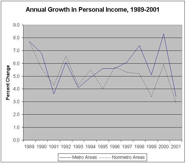
The gap in personal income growth rates for urban and rural areas in 2001 narrowed to its smallest amount since 1996, the last year that rural areas grew faster than urban areas, according to estimates released today by the U.S. Bureau of Economic Analysis. Personal income increased 3.4 percent for metropolitan areas and 2.9 percent for nonmetropolitan areas for a gap of 0.5 percent1.
Although personal income growth decelerated significantly in urban and rural areas in both 1991 and 2001, urban areas grew faster in 2001 while rural areas grew faster in 1991. In 2001, rural areas experienced slowdowns in growth in net earnings (earnings by place of residence) and in dividends, interest and rent from 2000 that were similar to those in urban areas, whereas in 1991, rural areas had an increase in the growth rate of dividends, interest, and rent from 1990.
1Personal income estimates are available only in current dollars.
In both 1991 and 2001, a decline in traditional durable goods manufacturing contributed to the economic slowdown. A decline in construction also contributed to the slowdown in 1991, while a decline in high-tech industries contributed to the slowdown in growth in 2001.
Growth Rates of Personal Income Components: 1990-1991 and 2000-2001
United States: Metro and Nonmetro Areas |
| |
Dividends, Interest |
|
| |
Personal Income |
Net Earnings |
and Rent |
Transfer Payments |
| |
2000 |
2001 |
2000 |
2001 |
2000 |
2001 |
2000 |
2001 |
| |
| United States |
8.0 |
3.3 |
7.8 |
2.4 |
10.6 |
2.4 |
5.1 |
9.4 |
| Metro Areas |
8.3 |
3.4 |
8.2 |
2.6 |
10.7 |
2.4 |
5.1 |
9.4 |
| Nonmetro Areas |
5.9 |
2.9 |
4.9 |
1.1 |
9.7 |
2.6 |
5.3 |
9.2 |
| |
| |
Dividends, Interest |
|
| |
Personal Income |
Net Earnings |
and Rent |
Transfer Payments |
| |
1990 |
1991 |
1990 |
1991 |
1990 |
1991 |
1990 |
1991 |
| |
| United States |
6.6 |
3.7 |
6.2 |
2.6 |
5.9 |
2.0 |
10.1 |
12.6 |
| Metro Areas |
6.8 |
3.6 |
6.3 |
2.6 |
6.6 |
1.7 |
10.2 |
12.7 |
| Nonmetro Areas |
5.6 |
4.3 |
5.6 |
2.5 |
2.5 |
3.2 |
9.5 |
12.3 |
Comparison of rural and urban areas by BEA Region, 2001 and 1991
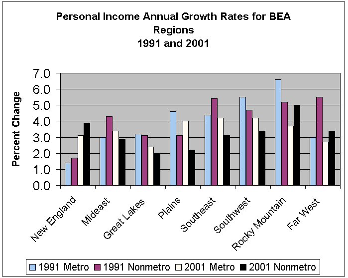
The slow growth years of 2001 and 1991 had some differing effects on the rural and urban areas of BEA regions. The slowdown of 2001 most adversely affected the rural and urban areas of the Great Lakes Region, the rural areas of the Plains Region, and the urban areas of the Far West Region, while the entire New England Region was most affected by the 1991 slowdown.
In 2001, slow growth in net earnings—primarily due to a decline in durable goods manufacturing—most affected the Great Lakes Region. In 1991, net earnings—primarily in construction and durable goods manufacturing—and dividends, interest, and rent declined in New England.
The range of personal income growth was more narrow across the BEA regions in 2001 than it was in 1991. In 2001, growth in personal income ranged from 5.0 percent in the rural areas of the Rocky Mountain Region to 2.0 percent in the rural areas of the Great Lakes Region. In 1991, personal income growth ranged from 6.6 percent in the urban areas of the Rocky Mountain Region to 1.4 percent in the urban areas of the New England Region.
Personal Income Growth by Metropolitan Area, 2001
Four of the six metropolitan areas in the greater San Francisco area (San Jose, Santa Cruz-Watsonville, San Francisco, and Santa Rosa)2 had personal income declines in 2001, after being among the fastest growing metro areas in the Nation in 2000. The 2001 declines in the greater San Francisco area are due primarily to a decline in information technology (IT) industries3. San Jose, CA, which had the fastest growth in personal income in 1999 and 2000, had the largest decline in 2001 at -6.9 percent.
| Personal Income Growth Rates for San Francisco-Oakland-San Jose, CA (CMSA) |
| |
| |
Percent change |
Ranking |
| |
2000 |
2001 |
2000 |
2001 |
| United States |
8.0 |
3.3 |
.. |
.. |
| |
| San Jose, CA |
22.9 |
-6.9 |
1 |
318 |
| Santa Cruz-Watsonville, CA |
15.8 |
-2.7 |
3 |
316 |
| San Francisco, CA |
18.4 |
-1.7 |
2 |
314 |
| Santa Rosa, CA |
13.4 |
-0.2 |
6 |
308 |
| Oakland, CA |
14.0 |
1.7 |
5 |
266 |
| Vallejo-Fairfield-Napa, CA |
10.5 |
2.3 |
20 |
234 |
Other metropolitan areas with large percentages of IT industries like Austin-San Marcos, TX, Boulder-Longmont, CO, and Seattle-Bellevue-Everett, WA also had declines in those industries in 2001. However, the effect on personal income was not as great because those areas had more industrial diversification than in San Jose, which had the highest percentage of IT earnings in the Nation. For example, Austin, Boulder, and Seattle all have large research universities located within their metropolitan areas.
2 Designated by the Office of Management and Budget as the San Francisco-Oakland-San Jose, CA consolidated metropolitan statistical area.
3 "Information Technology" industries include the following NAICS categories: Computer and Electronic Manufacturing; Internet Publishing; Telecommunications; Internet Service Providers, Search Portals, and Data Processing; and Professional and Technical Services.
Per Capita Personal Income, 2001
Despite having declines in per capita personal income (PCPI) in 2001, San Francisco and San Jose continue to have the highest PCPI levels in the Nation among metropolitan areas. San Francisco's PCPI of $57,714 was 190 percent of the Nation's PCPI of $30,413, while San Jose's PCPI of $51,579 was 170 percent of the Nation's average. Six of the 10 areas with the highest PCPI levels are from the New York-Northern New Jersey-Long Island consolidated metropolitan statistical area.
| The 10 Metropolitan Areas with the Highest Per Capita Incomes in 2001 |
| |
2000 |
2001 |
2000 |
2001 |
| |
| United States |
29,760 |
30,413 |
100 |
100 |
| |
| San Francisco, CA |
58,702 |
57,714 |
197 |
190 |
| San Jose, CA |
55,677 |
51,579 |
187 |
170 |
| New Haven-Bridgeport-Stamford-Danbury-Waterbury, CT |
47,286 |
48,453 |
159 |
159 |
| Bergen-Passaic, NJ |
42,799 |
43,856 |
144 |
144 |
| West Palm Beach-Boca Raton, FL |
41,945 |
43,626 |
141 |
143 |
| Middlesex-Somerset-Hunterdon, NJ |
43,051 |
43,292 |
145 |
142 |
| Newark, NJ |
41,291 |
42,550 |
139 |
140 |
| Trenton, NJ |
40,911 |
42,317 |
137 |
139 |
| Washington, DC-MD-VA-WV |
40,536 |
41,754 |
136 |
137 |
| Nassau-Suffolk, NY |
40,978 |
41,559 |
138 |
137 |
Three Texas border areas (McAllen-Edinburg-Mission, Brownsville-Harlingen-San Benito, and Laredo) had the lowest PCPI levels in 2001. However, due to above average personal income growth, the relative values of PCPI in 2001 for these border areas held steady despite having increases in population that were 2 to 3 times higher than the 1.1 percent increase of the Nation.
| The 10 Metropolitan Areas with the Lowest Per Capita Incomes in 2001 |
| |
Dollars |
Percent of U.S. |
| |
2000 |
2001 |
2000 |
2001 |
| |
| United States |
29,760 |
30,413 |
100 |
100 |
| |
| |
| Visalia-Tulare-Porterville, CA |
19,539 |
20,166 |
66 |
66 |
| Provo-Orem, UT |
19,046 |
19,271 |
64 |
63 |
| El Paso, TX |
18,398 |
19,186 |
62 |
63 |
| Auburn-Opelika, AL |
18,714 |
18,923 |
63 |
62 |
| Merced, CA |
18,268 |
18,461 |
61 |
61 |
| Las Cruces, NM |
17,090 |
17,984 |
57 |
59 |
| Yuma, AZ |
15,819 |
16,839 |
53 |
55 |
| Laredo, TX |
15,011 |
15,508 |
50 |
51 |
| Brownsville-Harlingen-San Benito, TX |
14,954 |
15,334 |
50 |
50 |
| McAllen-Edinburg-Mission, TX |
13,238 |
13,788 |
44 |
45 |
Note on 2001 NAICS
Beginning with 2001, earnings by industry estimates for local areas are based on the North American Industry Classification System (NAICS). Estimates of earnings by industry for 1969-2000 are based on the Standard Industrial Classification System.
Note about data on BEA Web site
The complete set of income and employment estimates for 1969-2001 for counties, metropolitan areas, and BEA Economic Areas is now available interactively on BEA's Web site. Detailed annual estimates of earnings and employment by industry, transfer payments (i.e. social security payments), and farm gross income and expenses by major category for each of the geographic regions are available. These estimates are the only detailed, broadly inclusive, annual measure of economic activity available for local areas. Go to www.bea.gov/regional/reis/ to access these estimates.
A narrative summary, BEA Regional Facts (BEARFACTS), of personal income, per capita personal income, and components of income for each metropolitan area and for counties for any ten-year period (i.e. 1991-2001) is available interactively on BEA's Web site. Go to www.bea.gov/regional/bearfacts/ to access these summaries.
Data on personal income and per capita personal income for BEA regions, states, and metropolitan areas, as well as data for counties, will be presented in the May issue of the Survey of Current Business, the monthly journal of the Bureau of Economic Analysis. See the end of this release for information on obtaining issues of the Survey of Current Business in printed form and on BEA's Web site. For further information, call (202) 606-5360.
Definitions
Personal income is the income received by all persons from participation in production, from government and business transfer payments, and from government interest. Personal income is the sum of net earnings by place of residence, rental income of persons, personal dividend income, personal interest income, and transfer payments. Net earnings is earnings by place of work (the sum of wage and salary disbursements, other labor income, and proprietors' income) less personal contributions for social insurance, plus an adjustment to convert earnings by place of work to a place-of-residence basis. Personal income is measured before the deduction of personal income taxes and other personal taxes and is reported in current dollars (no adjustment is made for price changes).
The estimate of personal income in the United States is derived as the sum of the state estimates; it differs from the estimate of personal income in the national income and product accounts (NIPA's) because of differences in coverage, in the methodologies used to prepare the estimates, and in the timing of the availability of source data.
Per capita personal income is the annual total personal income of residents divided by resident population as of July 1.
The metropolitan area definitions used by BEA for its personal income estimates are the county-based definitions issued by the Office of Management and Budget (OMB) for federal statistical purposes. OMB's general concept of a metropolitan area is that of a geographic area consisting of a large population nucleus together with adjacent communities having a high degree of economic and social integration with the nucleus. OMB recognizes two sets of metropolitan areas in the New England region. The first set is defined in terms of cities and towns; the second set, which is used for the estimates presented here, consists of the 12 New England county metropolitan statistical areas (NECMA's). Outside of the New England region, the metropolitan areas consist of 58 primary metropolitan statistical areas (PMSA's) and 248 metropolitan statistical areas (MSA's). The PMSA's and one NECMA are grouped into 17 consolidated metropolitan statistical areas (CMSA's). The 318 metropolitan areas discussed in the text of this release consist of the MSA's, PMSA's, and NECMA's. The estimates for all of the areas, including the 17 CMSA's, are shown in Table 1.
BEA's major national, international, regional, and industry estimates; the Survey of Current Business; and BEA news releases are available without charge on BEA's Web site:
Summary BEA estimates are available on recorded messages as follows: Gross domestic product, (202) 606-5306; personal income and outlays, 606-5303; and U.S. international transactions, 606-5362.
|
|